Simplify and optimize investment decisions in environmental assets
d-MRV, or digital Measurement, Reporting, and Verification, is a core technology in LandPrint, providing precise, real-time data to power informed environmental decision-making. Our d-MRV system builds on three steps:
They are defined through a rigorous science-based process by evaluating and adopting current leading monitoring frameworks and measurement standard.
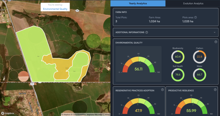
We follow rigorous internal protocols to generate all remote sensing data and advanced analytics. Additionally, we advise landowners on how to collect ground-truth data. All information is used in our platform to measure:
Environmental Assets: Carbon, biodiversity, water, and soil health.
Regenerative Practices: Sustainable land use.
Productive Resilience: Economic results of sustainable practices.
Each indicator is then rated against its maximum potential to assess its proximity to optimal conditions. What is the Maximum Potential of an Indicator or Environmental Asset?
This concept, coined by LandPrint, refers to the ideal maximum positive state of an indicator based on local factors such as weather, geography, land use, and economic conditions. For environmental assets, this benchmark serves as a proxy to evaluate their optimal ability to provide ecosystem services—including carbon sequestration, biodiversity, water regulation, and soil health—when managed under the best environmental and sustainable practices. LandPrint’s d-MRV platform uses science-based measurements and field evidence to define the maximum potential for each indicator.
Some of the measurement standards and criteria we align with include:
Simplify and optimize investment decisions in environmental assets
d-MRV, or digital Measurement, Reporting, and Verification, is a core technology in LandPrint, providing precise, real-time data to power informed environmental decision-making. Our d-MRV system builds on three steps:
They are defined through a rigorous science-based process by evaluating and adopting current leading monitoring frameworks and measurement standard.
We follow rigorous internal protocols to generate all remote sensing data and advanced analytics. Additionally, we advise landowners on how to collect ground-truth data. All information is used in our platform to measure:
Environmental Assets: Carbon, biodiversity, water, and soil health.
Regenerative Practices: Sustainable land use.
Productive Resilience: Economic results of sustainable practices.
Each indicator is then rated against its maximum potential to assess its proximity to optimal conditions. What is the Maximum Potential of an Indicator or Environmental Asset?
This concept, coined by LandPrint, refers to the ideal maximum positive state of an indicator based on local factors such as weather, geography, land use, and economic conditions. For environmental assets, this benchmark serves as a proxy to evaluate their optimal ability to provide ecosystem services—including carbon sequestration, biodiversity, water regulation, and soil health—when managed under the best environmental and sustainable practices. LandPrint’s d-MRV platform uses science-based measurements and field evidence to define the maximum potential for each indicator.
Some of the measurement standards and criteria we align with include: